AutoCAD Integration

AutoCAD Data Conversion in a Geodatabase

Problem and Objective

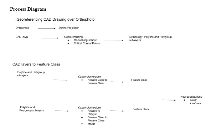
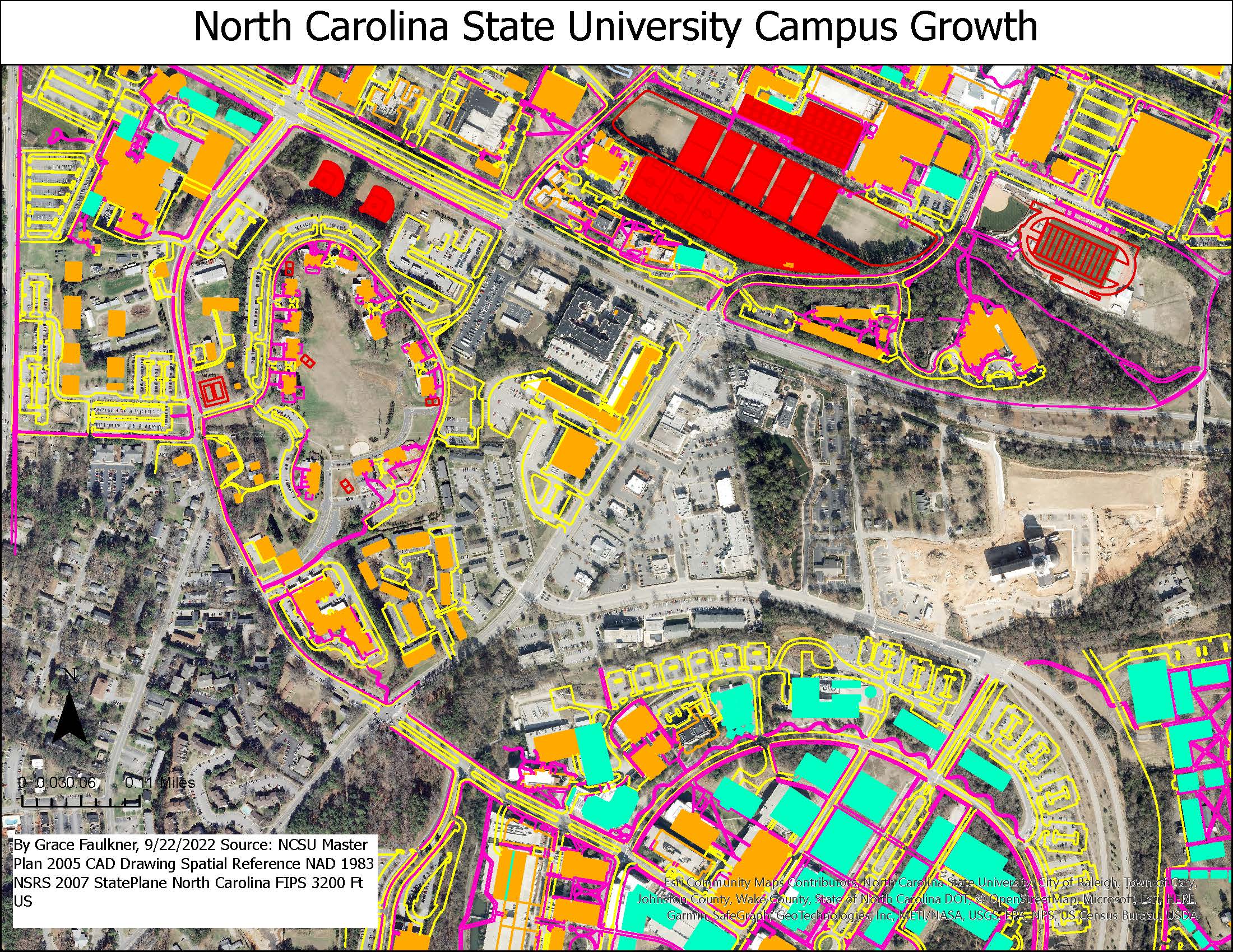
Working with GIS often means working with a myriad of data formats and using alternate file formats. For instance, Computer Aided Drafting (CAD) is often integrated into GIS analyses despite being a completely different technology. ESRI has developed a process of CAD data conversion to a geodatabase feature class and vice versa.  This conversion allows GIS users the ability to share, utilize and manage different CAD file types. The objective of this exercise was to georeference and convert CAD datasets in ArcGIS Pro. For example, North Carolina State University interested in campus growth and would like to spatially analyze the existing and future infrastructure. I created a geodatabase from a provided masterplan Computer Aided Design (CAD) data and orthophoto of campus. At the end of this exercise, I learned the basic data structure of CAD data compared to ESRI format feature classes, georeferenced a CAD dataset in ArcPro and performed a data conversion from CAD format to a geodatabase. 

Analysis Procedures
CAD data can be visually displayed and analyzed using georeferencing and conversion tools even though it is not usually aligned with a coordinate system.   For this exercise, I used various tools in the AutoCAD Georeference ribbon and Conversion toolbox in order to project an orthophoto of campus, add a CAD drawing on top and create a geodatabase and new feature classes. The primary input data, CAD drawing file and campus orthophoto, were provided by the instructor.
For this exercise, I projected an orthophoto of campus onto the NAD 1983 StatePlane North Carolina FIPS 3200 coordinate system using the Define Projection tool and then added a CAD drawing on top. The CAD drawing had two primary layers of interest that were used to create 6 new feature classes. First, the AutoCAD layers were properly positioned on top of campus, using the Georeference ribbon, manual adjustment and critical control points. Then, subgroup layers of interest (streets, buildings, sidewalks, streams, lakes, and athletic fields) were highlighted by changing the symbology. Next, the highlighted layers were converted to feature classes using alternate methods such as the tools Feature Class to Feature Class and Feature to Polygon in the  Conversion toolbox. For instance, the newly created feature class “Buildings” was merged from subgroups in the layers polyline and polygroup to include both existing and future buildings. Finally, the feature classes were then added to a new geodatabase with the Copy Feature tool.
Results 
NCSU Main Campus Academic Buildings, Athletic Fields, Sidewalks and Streets
Application and Reflection 
GIS users will often interact with different stakeholders who provide alternate data formats. Thus, it is important for GIS analysts to understand how to incorporate and convert these sources into GIS software. In this exercise, CAD data was used, a scaled data format that can be connected to a coordinate system but is often not. Fortunately, ArcGIS Pro can read a CAD drawing and convert either a whole feature dataset or feature layers. This is especially useful for successful coordination of projects between spatial analysts and engineers, designers or architects. In this project, the university was interested in campus expansion and the maintenance of existing and future facilities. However, this could be applied to the development of community spaces in urban spaces.
  • Problem Description: EPA Brownfield Sites are revitalization projects of previously compromised areas. Spatial analysts, city planners, and engineers could work together to develop a community park that is easily accessible and safe from contamination. Using development plans and orthoimagery, GIS analysists could produce a map to visually display the projected change of the area. 
  • Data Needed: In order to develop a new community park, a GIS analyst would need a CAD drawing of the newly designed park (blueprint of what the site will look like) from project partners, an orthophoto of the site (what the site currently looks like), and geospatial information on existing infrastructure and resources such as access to water or power lines to park. Orthoimagery can be obtained from the National Map Downloader. In the CAD drawing, polyline and polygroup feature classes of interest such as buildings, athletics fields, lakes/ponds, streets, and sidewalks would need to be specified in order to create similar feature classes in the geodatabase. 
  • Analysis Procedures: After obtaining the CAD drawing and orthophoto, the orthophoto would need to be  projected and the CAD dataset would need to be manually moved and georeferenced  over the photo. Once in place, the  feature classes of interest could be visually symbolized and displayed to show the projected changes to the area.